Introduction to Tropical Cyclone Nivar
Tropical Cyclone Nivar stormed onto the scene, capturing the attention of meteorologists and residents alike. With its swirling winds and torrential rains, it served as a powerful reminder of nature’s fury. But what exactly goes into the making of such a tempest? Understanding tropical cyclones is crucial for predicting their paths and minimizing damage.
In the case of Tropical Cyclone Nivar, scientists carefully monitored atmospheric conditions to forecast its intensity and potential landfall zones. Studying events like Tropical Cyclone Nivar helps improve global meteorological models and disaster preparedness strategies.
In this blog post, we will explore the science behind Tropical Cyclone Nivar. From its formation to its far-reaching impacts on coastal regions, each aspect contributes to our understanding of these formidable weather events. Join us as we delve into the intricate world of meteorology that helps us track storms like Nivar and learn how communities can better prepare for future cyclonic threats.
The Formation of a Tropical Cyclone
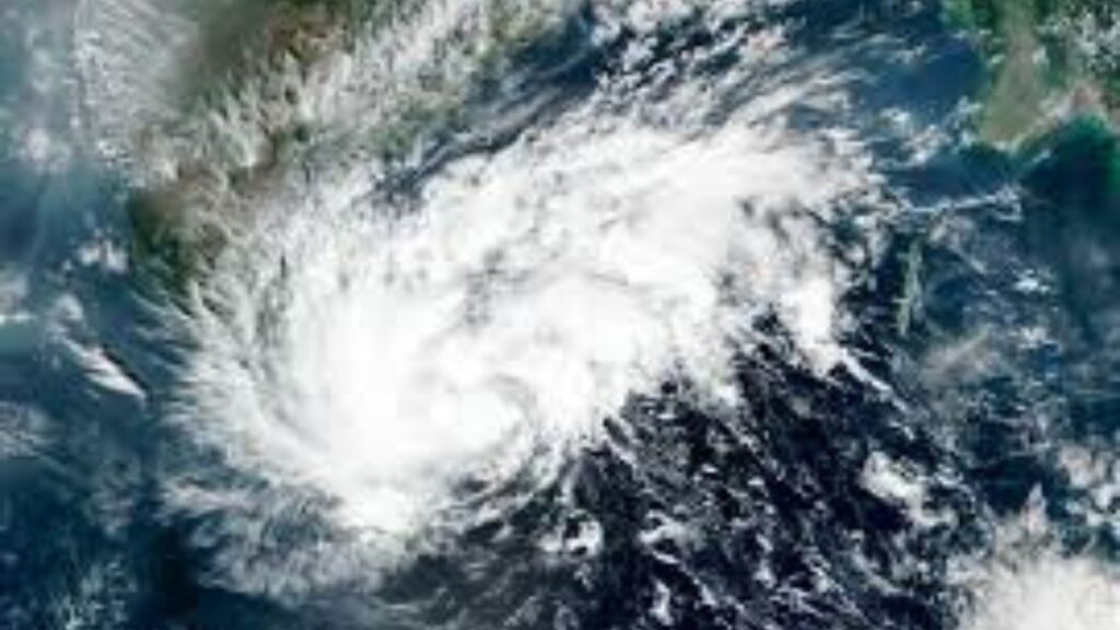
Tropical cyclones begin to form over warm ocean waters, typically when sea surface temperatures exceed 26 degrees Celsius. This warmth provides the necessary energy for storm development.
As moist air rises from the ocean, it cools and condenses into clouds. This process releases latent heat, further energizing the cyclone. The rising air creates an area of low pressure beneath it.
Surrounding high-pressure areas push more air towards this low-pressure zone. As this new air warms and rises, a cycle begins that can intensify rapidly under favorable conditions.
Wind patterns play a crucial role in shaping these storms too. The Coriolis effect helps spin the system, giving rise to rotation around a central eye as it gains strength.
Humidity and vertical wind shear also impact formation. When conditions align perfectly, a tropical depression may evolve into a full-fledged tropical cyclone capable of significant destruction—exactly how Tropical Cyclone Nivar developed over the Bay of Bengal.
Key Conditions Required for Tropical Cyclone Formation
| Meteorological Factor | Required Condition | Role in Cyclone Formation |
|---|---|---|
| Sea Surface Temperature | Above 26°C | Provides heat energy to fuel storm development |
| Atmospheric Moisture | High humidity levels | Supports cloud formation and thunderstorm activity |
| Coriolis Effect | Sufficient distance from equator | Enables rotational movement of the cyclone |
| Low Vertical Wind Shear | Minimal wind variation with height | Allows storm structure to remain intact |
| Pre-existing Disturbance | Tropical wave or low-pressure system | Acts as the initial trigger for cyclone formation |
Factors that Influence the Intensity and Path of a Cyclone
The intensity and path of a tropical cyclone are influenced by several key factors. Sea surface temperatures play a crucial role; warmer waters provide the necessary energy for cyclones to strengthen.
Wind patterns also significantly impact their trajectory. The presence of high or low-pressure systems can steer the cyclone in different directions, altering its potential landfall area.
Humidity levels in the atmosphere contribute to storm development as well. Increased moisture helps fuel thunderstorms, which can intensify cyclonic activity.
Additionally, topography matters. Mountains and coastal features can disrupt wind flow and influence storm behavior once it makes landfall. These elements influenced how Tropical Cyclone Nivar behaved before and after landfall.
Meteorologists continuously study these factors to refine forecasting models, making it possible to anticipate shifts in a cyclone’s strength or direction more accurately as they evolve over time.
Major Environmental Factors Affecting Cyclone Intensity
| Factor | Impact on Cyclone Strength | Example During Tropical Cyclone Nivar |
|---|---|---|
| Warm Ocean Water | Fuels storm intensification | Bay of Bengal waters boosted storm strength |
| Atmospheric Moisture | Enhances thunderstorm formation | High humidity supported rainfall bands |
| Vertical Wind Shear | Weak shear strengthens storms | Low shear allowed Nivar to organize |
| Ocean Heat Content | Sustains cyclone energy | Deep warm waters maintained intensity |
| Land Interaction | Weakens storm after landfall | Friction reduced wind speeds inland |
Tracking and Predicting Cyclones: Role of Meteorological Agencies
Meteorological agencies play a crucial role in tracking and predicting Tropical Cyclone Nivar. They utilize advanced satellite technology to monitor cloud formations, wind patterns, and ocean temperatures. These observations help forecasters identify potential cyclone development.
Models created by meteorologists analyze vast amounts of data. These simulations predict the path and intensity of a storm over time. By combining historical data with real-time updates, scientists can make informed decisions about future cyclone behavior.
Collaboration between global meteorological organizations enhances accuracy. Agencies share information across borders, ensuring timely alerts for affected regions. This teamwork is vital during severe weather events such as Tropical Cyclone Nivar.
Public communication is key as well. Meteorologists translate complex forecasts into understandable warnings for communities at risk. Their efforts save lives by informing people when to evacuate or prepare for impact from storms like Tropical Cyclone Nivar.
Key Tools Used in Cyclone Forecasting
| Forecasting Tool | Purpose | Importance in Cyclone Monitoring |
|---|---|---|
| Weather Satellites | Monitor cloud movement and storm structure | Provide real-time storm imagery |
| Doppler Radar | Detect rainfall intensity and wind speed | Helps track cyclone landfall |
| Ocean Buoys | Measure sea temperature and wave activity | Identify favorable storm conditions |
| Numerical Weather Models | Predict storm path and intensity | Improve forecast accuracy |
| Aircraft Reconnaissance | Direct storm observation | Collects high-precision atmospheric data |
Impact of Tropical Cyclone Nivar on Coastal Regions
Tropical Cyclone Nivar made landfall with significant repercussions for coastal regions. The heavy rainfall and strong winds wreaked havoc on infrastructure, leading to widespread flooding.
Coastal communities faced challenges as storm surges inundated low-lying areas. Roads were submerged, making transportation difficult and isolating many neighborhoods. Power outages became common as downed trees took out electrical lines.
Agriculture also suffered immensely. Fields flooded, destroying crops that had just reached maturity. Fishermen experienced losses too, as boats were damaged or washed ashore.
Emergency services worked tirelessly to rescue those trapped by rising waters. Shelters opened their doors for evacuees seeking refuge from the chaos outside.
Despite the destruction caused by Tropical Cyclone Nivar, community resilience shone through in recovery efforts. Neighbors came together to help each other rebuild what was lost after the storm passed.
Precautionary Measures and Evacuation Plans
When a tropical cyclone like Tropical Cyclone Nivar approaches, preparation becomes crucial. Authorities typically issue warnings well in advance. Staying informed through reliable news sources helps families make timely decisions.
It’s essential to have an emergency kit ready. This should include essentials such as water, non-perishable food, flashlights, and first-aid supplies. Don’t forget medications or special items for children and pets.
Evacuation plans must be clearly communicated to the public. Knowing local evacuation routes can save lives when time is of the essence. Designate a safe meeting place for family members if separated during an emergency.
Communities often set up shelters equipped to accommodate those displaced by the storm. Understanding these resources ahead of time allows residents to act quickly when necessary.
Engaging with local agencies can provide additional safety tips tailored to specific regions prone to cyclones like Tropical Cyclone Nivar. Community cooperation enhances overall preparedness and resilience against natural disasters.
Lessons Learned from Previous Cyclones
Cyclones have taught us valuable lessons over the years. Each storm brings insights that can improve future preparedness.
One key takeaway is the importance of timely communication. Rapid alerts can save lives by ensuring people are informed and ready to act.
Another lesson revolves around infrastructure resilience. Buildings and roads must be designed to withstand severe weather conditions, as seen in regions frequently affected by cyclones.
Community engagement plays a vital role too. Local groups trained in disaster response can make a significant difference during emergencies.
Past cyclones highlight the need for effective evacuation plans. Clear routes and accessible shelters are essential for safe relocation when storms approach.
Investing in technology has proven beneficial as well; advanced forecasting models enhance accuracy, helping communities plan better for impending threats similar to Tropical Cyclone Nivar.
Conclusion: Understanding and Preparing for Future Cyclones
As we reflect on the impacts and characteristics of Tropical Cyclone Nivar, it becomes clear that understanding these weather systems is crucial. The science behind their formation and behavior can help us mitigate risks associated with them.
Preparedness is key. Coastal regions must prioritize developing robust evacuation plans and informing communities about safety measures. Continuous education about cyclones allows residents to recognize warning signs and understand response protocols.
Meteorological agencies play a vital role in tracking storms like Tropical Cyclone Nivar, using advanced technology to predict their paths. This information is invaluable for timely evacuations and minimizing damage.
Each cyclone teaches us something new. By learning from past events, authorities can improve strategies for future storms. Staying informed empowers individuals to take proactive steps when facing the threat of cyclones.
Embracing knowledge helps us build resilience against nature’s forces while striving to protect lives and property in vulnerable areas.
FAQs
What was Tropical Cyclone Nivar?
Tropical Cyclone Nivar was a powerful cyclone that formed over the Bay of Bengal in November 2020, impacting parts of India and nearby coastal regions with heavy rainfall and strong winds.
How did Tropical Cyclone Nivar form?
Tropical Cyclone Nivar formed due to warm ocean waters, high atmospheric moisture, and favorable wind conditions that allowed a low-pressure system to intensify into a cyclone.
Why was Tropical Cyclone Nivar significant for meteorologists?
Meteorologists studied Tropical Cyclone Nivar to improve forecasting models, understand storm intensification patterns, and refine early-warning systems for future cyclones.
How do meteorological agencies track Tropical Cyclone Nivar?
They use satellites, radar systems, ocean buoys, and computer-based weather models to monitor the cyclone’s development, path, and intensity.
What safety precautions should be taken during cyclones like Tropical Cyclone Nivar?
People should follow evacuation orders, prepare emergency kits, stay updated through official warnings, and move to designated shelters when necessary.